|
Digital-Desert :
Mojave Desert
|
| Intro:: Nature:: Geography & Maps:: Parks & Preserves:: Points of Interest:: Ghosts & Gold:: Communities:: Roads & Trails:: People & History:: |
West Side Road:
Shoreline Butte
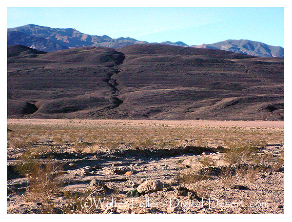
Look carefully and you can see several horizontal lines carved into the northeast flank of Shoreline Butte. These lines are actually flat terraces called strandlines that are cut into the hillside by waves battering the shore. It takes some time for waves to gnaw away terraces like these, so these benches provide records of times when the lake level stabilized long enough for waves to leave their mark on the rock. The highest strandline is one of the principle clues that geologists use to estimate the depth of the lake that once filled Death Valley. Lake ManlyShorelines of ancient Lake Manly are preserved in several parts of Death Valley, but nowhere is the record as clear as at Shoreline Butte. ... |
|
| Intro:: Nature:: Geography & Maps:: Parks & Preserves:: Points of Interest:: Ghosts & Gold:: Communities:: Roads & Trails:: People & History:: |
|
Digital-Desert :
Mojave Desert
|
|
Country Life Realty Wrightwood, Ca. |
Mountain Hardware Wrightwood, Ca. |
Canyon Cartography |
G.A. Mercantile |
Grizzly Cafe Family Dining |
|
Abraxas Engineering privacy |
Some content is based on reconstructed historical context and has been reviewed for accuracy; interpretation may evolve. For educational use only; not a travel or safety guide. Copyright © Walter Feller, 1995–2026. All rights reserved. |