|
Digital-Desert :
Mojave Desert
|
| Intro:: Nature:: Map:: Parks:: Points of Interest:: Ghosts & Gold:: Communities:: Roads & Trails:: People & History:: BLOG:: Weather:: :?:: glossary |
|
|
Wilderness - MAP 
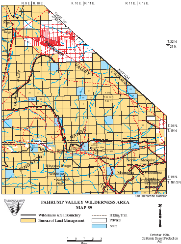
Pahrump Valley >> Map #59 Pahrump Valley Wilderness SIZE: 74,800 acres LOCATION: San Bernardino and Inyo Counties; 25 miles east of Tecopa, California NATURAL RESOURCES: Alluvial fans in California, Pahrump and Mesquite Valleys ascend southward into the Kingston Range. The range is rugged, with many canyons, bajadas and winding washes. Elevations range from 2,720 feet to a 4,569-foot summit. The California, Mesquite and Pahrump Valleys, for which the area is named, are dotted with desert shrubs. Several plant species dependent upon limestone soils grow in the area, as well as unusual yucca species. Desert tortoise, golden eagles and desert bighorn sheep have been seen here.
ACCESS: Access this wilderness via the Excelsior Mine Road from Interstate 15, or the Old Spanish Trail Highway. |
|
| Intro:: Nature:: Map:: Parks:: Points of Interest:: Ghosts & Gold:: Communities:: Roads & Trails:: People & History:: BLOG:: Weather:: :?:: glossary |
|
Digital-Desert :
Mojave Desert
|
|
Country Life Realty Wrightwood, Ca. |
Mountain Hardware Wrightwood, Ca. |
Canyon Cartography |
G.A. Mercantile |
Grizzly Cafe Family Dining |
|
Abraxas Engineering privacy |
Disclaimer: Some portions of this project were developed with assistance from AI tools to help reconstruct historical contexts and fill informational gaps. All materials have been reviewed and fact-checked to ensure accuracy and reliability, though complete precision cannot be guaranteed. The aim is to provide dependable starting points and distinctive perspectives for further study, exploration, and research. These materials are historical in nature and intended for educational use only; they are not designed as travel guides or planning resources. Copyright - Walter Feller. 1995-2025. All rights reserved. |