Digital-Desert : Mojave Desert
Intro:: Nature:: Geography & Maps:: Parks & Preserves:: Points of Interest:: Ghosts & Gold:: Communities:: Roads & Trails:: People & History::

Wilderness - MAP
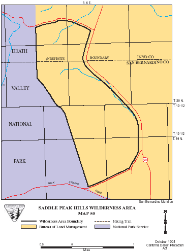
Saddle Peak Hills >> Map #50

Saddle Peak Hills Wilderness

SIZE: 1,440 acres

LOCATION: San Bernardino County; 38 miles north of Baker, California

NATURAL RESOURCES: This area includes the Saddle Peak Hills, which form the western three quarters of the wilderness and the northwestern portion of the Silurian Valley. The wilderness sits adjacent to the Death Valley National Park. The hills are cut by curvy faults and range in elevation from 500 feet on the valley floor to 2,500 feet. The features preserved here represent common landforms found throughout the surrounding desert and mountains.

GLOSSARY > desert

ACCESS: Access this wilderness from State Highway 127.


Intro:: Nature:: Geography & Maps:: Parks & Preserves:: Points of Interest:: Ghosts & Gold:: Communities:: Roads & Trails:: People & History::
Digital-Desert : Mojave Desert
Country Life Realty
Wrightwood, Ca.
Mountain Hardware
Wrightwood, Ca.
Canyon Cartography
G.A. Mercantile


Grizzly Cafe
Family Dining


Abraxas Engineering
privacy

Some content is based on reconstructed historical context and has been reviewed for accuracy; interpretation may evolve. For educational use only; not a travel or safety guide. Copyright © Walter Feller, 1995–2026. All rights reserved.